The Waterkloof Trail is the longer of two hikes starting from Naukluft Camp, a 25-minute drive southwest of Buellsport in the Namib Naukluft National Park.
TOBINKA
Travel guide | Namibia
The most incredible places in Namibia to visit in 14 days
Text | Anninka Kraus
Photography | Tobias Kraus

Namibia
Around midday, most places in Namibia are a desaturated wilderness, painted in subtle earth tones of the African savannah.
Only the sunrise and sunset brushed a bountiful palette of reds and yellows on the sky and splashed more on the barren grassland dappled with camelthorn trees.
The sunset colours are particularly bold, saving the grand finale for last: A bluish black canvas studded with the billions of stars in the Milky Way Galaxy.
jump ahead.


When a yellow-orange glow trails the horizon and intensifies in colour just before the sun erupts behind a dune’s sharp contours, the sand turns a vibrant red colour.
Namibia Map for 10-day Road Trip
what to expect.
A desaturated wilderness, painted in subtle earth tones of the African savannah
Stunning sunrises and sunsets that brush a bountiful palette of reds and yellows on the sky and splash more on the barren grassland dappled with camelthorn trees
The Namib Desert where sharp lines separate the light blue of the sky from the red dunes
Waterberg – a table mountain topped by red sandstone that rises unexpectedly from the vast plain of the Kalahari Desert
location & itinerary information.
Namibia 14-day Road Trip Itinerary:
Additional destination for 3-week itinerary: The Fish River Canyon near the South African border. This is Africa’s largest canyon, and by some accounts even the second largest canyon in the world.
Day 1: Windhoek to Naukluft
Day 2-3: Naukluft Mountains
Day 4-5: Namib Desert
Day 6-7: Swakopmund and Walvis Bay
Day 8-9: Spitzkoppe and Kamanjab
Day 10-12: Etosha
Day 13-14: Waterberg and Return to Windhoek
Day 1: Windhoek to Naukluft
Most visitors to the country will arrive in Windhoek. Personally, I wouldn’t spend much time there.
The only things I recall after an hour spent walking through this singularly unappealing city was a nice church and clean toilets at Nandos.
From Windhoek it’s a 3-hour drive into the Naukluft Mountains.
Day 2-3: Naukluft Mountains
The southern section of this mountain range is part of the Namib-Naukluft National Park and best explored on the 10km Olive Trail (3-4hours) and 17km Waterkloof Trail (5-7hours).
Both trails followed dry riverbeds into narrow, shady gorges hemmed in by red canyon walls.
Day 4-5: Namib Desert
The Namib Desert is situated within Africa’s third largest National Park, the Namib-Naukluft Park that encompasses almost 50.000km2.
Here you’ll see the most stunning sunrises and sunsets.
Spend at least a day exploring Deadvlei and Sossusvlei, two beige, bone-dry clay pans with their remarkable dead camelthorn trees, many hundreds of years old, preserved by the dry climate
Day 6-7: Swakopmund and Walvis Bay
Visit Walvis Bay, a city on the Atlantic coast that is famous for large groups of flamingos flocking to the lagoon.
30km north of Walvis Bay, on the coast but surrounded by the Namib Desert on all sides, lies Swakopmund. The self-proclaimed adventure capital of Namibia was founded by German settlers towards the end of the 19th century and its German origins remain deeply ingrained in the town’s colonial architecture, the pretzels, Currywurst and Hax’n, and decidedly German names of roads, hotels, and restaurants.
Day 8-9: Spitzkoppe and Kamanjab
Explore the iconic inselbergs of Spitzkoppe – bald granite peaks rising 700m above the arid Namib floor of southern Damaraland – 120km northeast of Swakopmund.
Plan in a visit to a Himba village near Kamanjab.
Day 10-12: Etosha
Go on safari in Etosha National Park, Namibia’s greatest wildlife reserve, located in north-western Namibia. The park is half the size of Switzerland and home to an abundance of wildlife and 4 of the Big 5, including the seriously endangered black rhino.
Especially in the dry season, you are guaranteed exceptional wildlife sightings at the park’s many waterholes.
Day 13-14: Waterberg and Return to Windhoek
Explore Waterberg (Afrikaans for ‘water mountain’): a table mountain topped by red sandstone that rises unexpectedly from the vast plain of the Kalahari Desert, 3 hours north of Windhoek.
Return to Windhoek.
When to go: In the dry season, from June/July to October, when there’s hardly any rain and wildlife gathers around the permanent waterholes.
Hiking in Namibia's desert
Naukluft Mountains
Ninety kilometres (1.5 hours) northeast of Sesriem Gate, the gateway into the Namib Desert, Naukluft Camp hides in the Naukluft Mountains, at the end of a long dirt track forking off Pad D854 just before Buellsport. The southern section of this mountain range is part of the Namib-Naukluft National Park and best explored on the 10km Olive Trail (3-4hours) and 17km Waterkloof Trail (5-7hours).
Both trails followed dry riverbeds into narrow, shady gorges hemmed in by red canyon walls that were occasionally adorned with yellow flowering palm trees and large succulent cacti. Both also cut across the top of a barren plateau with views of equally barren cliff ledges, canyons and plains rolling towards the horizon that to me symbolised the sparsely populated vastness of Namibia.
But the infinite expanse of this country truly only hit home on the six-hour journey north to the Waterberg Plateau. We’d drive for more than an hour, across rough dirt roads and trailing a giant orangey dust cloud that rendered our rear view mirror useless, without passing another car. We also drove for almost 200 kilometres without a petrol station in reach. For this reason it’s imperative to fill up the car with petrol at every given opportunity when travelling off the beaten track in Namibia. And most of the country is off the beaten track in fact.
We’d have liked to see still more of the mountains on the 4 or 8-day Naukluft Trail but a party of three is the smallest group allowed on the trail. NRW does not run a forum to team up with fellow hikers beforehand, which for us proved impossible on the dates we wanted to go.
Waterkloof Trail and Olive Trail in the Naukluft Mountains.
Hiking the Olive Trail in the Namib Naukluft National Park
The 10km Olive Trail in Namib Naukluft National Park offers sweeping views of reddish-brown plains and mountain ranges stretching in endless succession.
The best spots to watch the sunset in the Namib Desert
I slid down Big Daddy – at 350m one of the world’s highest dunes – in giant strides and sank into very fine red sand to halfway up my calf. The sand was painfully cold to my feet and turned my toes numb but I felt the sun gain in intensity quickly. We’ve spent time in this desert before.
Still I was surprised by the huge temperature changes. Upon a scorching hot day always follows a frigid night.
Temperatures dip to single digits, sometimes even below freezing point. I normally avoid the cold at all cost, but not here. It’s at the time of chilly twilight, when we scrambled up the dune along its fine ridge line that was smudged by the footprints of a Japanese family climbing up before us, that the desert is most fascinating. When a yellow-orange glow trails the horizon and intensifies in colour just before the sun erupts behind a dune’s sharp contours.
We learnt much about this desert – one of the oldest in the world – on our last visit here, on an overland tour through southern Africa. While on the surface the desert appeared to be an uninhabitable wasteland, many plants and animals have adapted to the harsh conditions with surprising ingenuity.
A local guide then told us of small beetles drinking the droplets of condensation that collects on their backs and on the roots of plants, persevering that way in the sand for years, patiently waiting for the next sparse and highly unpredictable rainfall. When it actually does rain, the desert is apparently green, but it rains little – maybe 2mm per year, some years not at all, and in a very wet year only up to 300mm.
Germany’s yearly precipitation in comparison averages 700mm. Maybe that is an unjust comparison however because snowfall is included in these statistics and the Namib Desert hasn’t seen snow since the last ice age.
The Namib Desert is situated within Africa’s third largest National Park, the Namib-Naukluft Park that encompasses almost 50.000km2. It’s a popular tourist sites in Namibia yet was surprisingly deserted at the time of our visit. We stayed at Sesriem Campsite, the only camping ground located inside the exterior park gates.
Their guests are allowed entry to the park one hour before and after other visitors. It was still pitch-dark when we joined the line of headlights queuing at the gate at 6:15am. All of us wanted to watch the sun rise from the top of Elim Dune and Dune 45, located 5km and 45km from the camp respectively. When we rushed back in the gates after sunset when the sky was still dyed the colours of a rainbow but with a deeper, more luscious glow than rainbows bring forth, we were basically the last to leave.
In between, from mid-morning until late afternoon, we returned to the camp. High temperatures at noon make the drudgery through soft sand more strenuous and harsh sunlight robs the Namib of its intense colours and fascinating distinct shapes and turns it into a barren, monotonous wasteland.
Dead-end marsh
Deadvlei and Sossusvlei
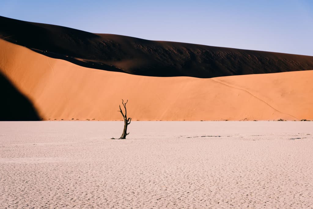
The morning colours in the Namib are few and the sharp lines that separate the light blue of the sky from the red dunes and the beige clay pan of Sossusvlei intensify their striking contrast. Devoid of vegetation, except for the petrified trees that have gained worldwide popularity, the desert was uncluttered. I stood barefoot on cracked clay, soaking up the sun, and there was nothing to distract my attention from the clear-cut lines of the dunes and the light changing with every minute.
Sossusvlei literally translates to dead-end marsh. About once every ten years, after exceptional rainfalls, the Tsauchab River floods the vlei (pan) and forms a lake that slowly evaporates, but when we visited it was bone-dry and barren. The nearby Deadvlei, which means dead marsh, is cut off from the river by large sand dunes and never floods, its remarkable dead camelthorn trees, many hundreds of years old, preserved by the dry climate, stand forlorn, dotting the beige pan floor. While dead trees in a clay pan may not sound like much, the contrasting colours of the cracked clay, blackened tree skeletons, and red dunes were extraordinarily photogenic and a vivid illustration of life without water – meaning no life.
Sossusvlei unfortunately is too far from the gates to make it back in time after sunset. We managed a sunrise from halfway up Big Daddy however, but just. The tarred road ends 60km from Sesriem at a 2×4 parking, and 6km short of the Sossusvlei 4×4 parking. Drivers not experienced in ploughing through soft sand in a 4×4 should definitely stop at the first parking lot.
From there, NRW rangers operate a frequent shuttle service on the last 6km for 70N$pp one-way. Additionally to that service, they rescue drivers every morning who in the dark missed the 2×4 parking and drove on, as we did, or overestimated their driving skills. After a few hundred metres our car was bogged down in deep sand and I killed the engine in one slowly suffocating slur. To our left and right at the very same moment, a German and French couple suffered the same fate as us. Our cars, all 4x4s, were spread across the entire width of the track almost in a straight line.
We gave up on the cars and were all debating how to get to the dunes for sunrise when a kind ranger pulled up in an open top safari vehicle. He collected our car keys, dropped us off at the 4×4 parking and then returned our cars to the 2×4 parking. Thanks to him, we were halfway up the dune to witness the first long shadow cast over Sossusvlei and shrink hastily as the sun moved higher up in the sky and regained an ever greater part of the white crust pan.
Most visitors head into the dunes for sunrise. That moment is very special indeed but personally I enjoyed the hours around dusk even more. For one, the colours are bolder and seem to linger on the night sky indefinitely at dusk, saving the grand finale for last: A bluish black canvas studded with the billions of stars in the Milky Way Galaxy. And wriggling our toes in the still warm sand on Dune 45, the dazzling spectacle of sunset was a private show that we had to share with no one. It is this solitude that sets a sunset in the desert apart from all others.
At Sossusvlei, dead camelthorn trees, many hundreds of years old, preserved by the dry climate, stand forlorn, dotting the beige pan floor.
Walvis Bay & Swakopmund: German colonial heritage – Hax’n, currywurst, and pretzels
We crossed the Tropic of Capricorn today. It is indistinguishable from any other spot in the desert and if it hadn’t been for a sign marking the tropic, we would have driven past it to Walvis Bay without stopping.
Walvis Bay, a city on the Atlantic coast is famous for large groups of flamingos flocking to the lagoon. We stopped to watch these elegant yet awkward looking leggy birds perched on one leg while their other bent backward at what seemed to be the knee (though we learnt that it is indeed the ankle and heel), while truck after truck loaded with sea salt rolled past us heading for the harbour. The salt works south of the lagoon are one of the largest producers on the continent and export sea salt to neighbouring countries as well as Europe.
30km north of Walvis Bay, on the coast but surrounded by the Namib Desert on all sides, lies Swakopmund. The self-proclaimed adventure capital of Namibia was founded by German settlers towards the end of the 19th century and its German origins remain deeply ingrained in the town’s colonial architecture, the pretzels, Currywurst and Hax’n, and decidedly German names of roads, hotels, and restaurants – like the Kaiser Wilhelm Strasse, Brauhaus, Am Zoll Flats, and Hotel Grüner Kranz.
The temperature of 38 degrees in the shade in the desert that morning fell sharply to barely 20 degrees and overcast skies by the sea defeated our hopes of a beach day. Swimming was out of the question anyway, as water temperatures reached a mere 13 degrees.
Spitzkoppe - an iconic inselbergs in the middle of nowhere
As soon as we left Swakopmund and returned to the Namib Desert, the temperature soared to well above 30 degrees. It wasn’t long though before we spotted the iconic inselbergs of Spitzkoppe – bald granite peaks rising 700m above the arid Namib floor of southern Damaraland – 120km northeast of Swakopmund.
It is a spectacular sight from afar and the site is also well-known for its prehistoric Bushman cave paintings believed to date back 2000-4000 years. As a local guide explained these paintings were used for communication between tribes – a rhino’s head for instance pointed in the direction where water was found, and warlike paintings warned of hostile tribes in the area.
Inspecting the paintings, I recognised rhinos, skinny human shapes, and what I thought was an elephant but turned out to be an ant bear. The rest, according to the guide, were ostriches and fantasy shapes, and while Small Bushman Paradise was full of history, it somehow failed to inspire in me any sense of awe.
In the late afternoon we scrambled up the rock face of an inselberg to watch the sun set from a higher elevation. The sun’s rays had scorched the vast landscape all day but as their strength began to fade we witnessed the smooth rock face and barren plains colouring vibrant shades of yellow, orange, pink, and purple in turn. When this colour extravaganza yielded to the desaturated tones of dusk we slowly made our way down the escarpment again.
A visit to the Himba people in Kamanjab
Nomad’s description of our next activity – a visit to a Himba village near Kamanjab – explicitly stated that it would be, in no way, a ‘human zoo’ exhibition, but to me it was exactly that. The very fact that the tour company felt compelled to point out the opposite was reason to believe that others before us had similar reservations.
We were warmly welcomed in the village that consisted of small circular huts with pointed thatched roofs. The Himba tribe is polygamous, which explained why there were less than ten men, more than twenty women, and a swarm of small children. The women were topless but richly adorned with traditional necklaces and bracelets, and their skin and braided hair covered with an otjize paste of fat and red ochre for aesthetic reasons but also for protection against the harsh desert climate. As the Himba people never bathe in water (only smoke) this paste doesn’t need to be re-applied every day.
In contrast, the men of the tribe wore shorts, T-Shirts, and Nike sunglasses which were strangely out of place. Personally, we felt uncomfortable, like we were intruding in this environment, and disconcerted that toddlers begged with the same professionalism as adults, which is of course not to say that others may not gain something meaningful from this cultural exchange.
Dead-end marsh
Etosha National Park
This is surely the most popular of all the places to visit in Namibia and we were there already in 2012 although that visit was very different to our stay this time. Namibia’s greatest wildlife reserve was unchanged from what we could tell: A national park half the size of Switzerland in north-western Namibia that, surprisingly, is less known for its exceptional wildlife sightings at the park’s many waterholes than for the Etosha Pan.
This immense salt pan occupies almost a quarter of the park, approximately 5000km², which is large enough to be visible from space. The rest of Etosha is more habitable, grassland and mopane woodland, and home to an abundance of wildlife including the seriously endangered black rhino.
But camping at Halali and Okaukuejo rest camps on an African overland trip – the budget version at that – didn’t compare for the overall experience to Onguma Tented Camp. Technically we stayed in a tent both times but that’s where the similarities end.
The camp is situated on the Onguma Reserve, a 34’000 hectares private nature reserve bordering Fisher’s Pan on the eastern side of Etosha. In the language of the local Herero people ‘Onguma’ means ‘the place you don’t want to leave,’ and we didn’t indeed.
Tobi turned the car onto a small dirt track signposted ‘Onguma Tented Camp’ a second too late to notice a pothole blending in well with the ochre-coloured cracked clay. When eventually the track came to a dead end, 11km from the main entrance to the reserve, what we saw of the camp was a canopied car parking and two footpaths disappearing out of view.
The semi-arid landscape at noon was sun-parched and offered no shade. After a moment a staff member appeared, asked us to unload our bags and park the car, then ushered us towards the reception. The public area of the camp was divided into a lounge area that extended to the right of the reception, the large open dining room to its left, a small pool and large campfire area.
Furniture and decoration in contemporary African style were arranged around a fireplace and masonry stonewall that were the only elements of stone in what was essentially a large tent. The predominant muted shades of brown and green complemented the landscape well.
Luxury accommodation in itself hardly ever makes for a memorable stay and I still recall the basic huts on the Annapurna Circuit more vividly than any number of 5-star hotels.
Spreading back toward the Etosha Pans, the main building and seven luxury accommodation tents set in a sweeping semi-circle at an equal distance to a natural waterhole, however captured the adventurous spirit of Namibia perfectly. The wooden patio on stilts running the width of our tent and extending towards the waterhole was my favourite place on earth for three days.
I am an impatient person and the idea of watching a grey-haired ageing warthog with its shovel-faced head foraging for food for an hour should have bored me to death. It didn’t. Instead I strolled over to the pool fed directly through the borehole (a shaft bored in the ground to extract water) and sank into a deck chair. When I recovered from the 3-minute walk – this no-exercise routine of sleeping, eating and sitting for three days was exhausting – I continued watching the old warthog. It was unfazed by a harem of zebras, kudus, and three giraffes that strolled by, and the impalas that were a permanent feature at the waterhole. We could tell by the male’s roars and grunts that they stayed put even at night.
Never knowing what animals would turn up next was exciting. An excitement muted to pleasant anticipation by laziness, comfort and a lack of predators, rather than full of thrill. The thrill of the chase we experienced only once on safari, when we witnessed a lion hunt in the Serengeti. There is a healthy population of the lion, leopards and cheetah on the reserve actually but unfortunately none showed up at the waterhole. For safety reasons we were still accompanied to our hut by a staff member (armed with a torch) after dark.
The days blended seamlessly into a monotonous, slow motion rerun of life at the waterhole. I really can think of no other pastime when immobile idleness conveys such a great spirit of discovery and adventure. All it takes is a lounge chair in close proximity to a waterhole or sitting in an open top safari jeep.
Safari is not about sightseeing – animals in this case – but feeling overwhelmed and humbled by the authenticity and beauty of the experience: the hot, dry air blowing in my face, the animal and plant diversity found in this wilderness, sunset giving my pale skin a bronze glow, the pungent smell of a family of elephants romping about a waterhole and thrill of watching a female leopard with three cubs cross the savannah in search of dinner.
Zebras and giraffes gathered around a waterhole in Etosha National Park (left). Safari in the Serengeti (right).
Why you must visit Etosha National Park in Namibia
Etosha National Park is a national park in northwestern Namibia and the country’s greatest wildlife reserve.
On Safari in the Serengeti
The Serengeti National Park is a national park in Tanzania most famous for the largest annual migration of over 1.5 million blue wildebeest.
Namibia's water mountain
Hiking on the Waterberg Plateau
Waterberg is Afrikaans for ‘water mountain’ and refers to a table mountain topped by red sandstone that rises unexpectedly from the vast plain of the Kalahari Desert, 3 hours north of Windhoek. We planned to stay two nights at Waterberg Wilderness Private Nature Reserve in Waterberg Plateau Park off D2512 and walk six short unguided nature trails on their premises.
But a half-hour into our first hike on the Andersson Trail, a visibly agitated green snake rapidly slithered towards us with its head raised half a metre above ground. From what we could tell, it was 2-3m long and about 5cm in diameter. Terrified, we scrambled back down the trail on wobbly knees. When I turned back, the reptile had disappeared into the tangled undergrowth again. To join the dozen more lurking in the bushes was my paralysing thought all the way back to the camp. A half-hour later, I still jumped in fright at the sound of rustling leaves as a bird took flight.
In this wilderness, a 3-hour drive to the nearest hospital, I would not risk snakebite on another unguided walk at Waterberg. With Johann, a hiking guide of the local San (bushmen) people, I felt reasonably safe on the Plateau Hike the next morning however. Starting from Wilderness Lodge at 8am, he took a small group of visitors up to the top of Waterberg Plateau that is only accessible with a guide in any case.
On the 5.3km loop walk we discovered prints and droppings of the rhino, buffalo, baboon, snake (of course there were more) and antelope, and encountered a giraffe feeding off the treetops. Fortunately the lions and leopards roaming the national park stayed out of sight. I didn’t quite see how Johann, though knowledgeable that he was about the bush and its plants and animals, would defend our group with his wooden hiking stick in case of an unexpected encounter with one of the large cats.
Two hours into the hike we arrived at sundowner viewpoint. On the southeastern rim of the plateau, this spot overlooks the red vast sand plain of the Kalahari Desert. It is named a desert, but studded with shrubs and camelthorns it actually looked more like a semi-arid savannah. In any case it was vast, this tiny part of the Kalahari that we saw. To think it actually stretches some 900.000 square kilometres across Botswana, South Africa, and Namibia was hard to grasp.
Inside Fish River Canyon, one of the world’s largest canyons
The Fish River Canyon is a 160km long, 27km wide, and up to 550m deep gorge slicing its way through reddish brown gneiss rock. It is Africa’s largest canyon, and by some accounts even the second largest canyon on earth (only the Grand Canyon is larger).
We descended to halfway inside the canyon and were enthused by the beauty of bare rock sans vegetation rising narrow and tall and blotting out the sunlight.
The most memorable impression however was the view from the cliff ledge as the sunset reddened the gorge and gradually the orange glowing rock turned grey with dusk which also brought with it a sudden and welcome drop in temperature.
Sharing our love of the Outdoors – Hiking & Travel Guides by tobinka