Hike | South Island | New Zealand
Guide to the Great Alpine Highway & best hikes in Arthur’s Pass
Text | Anninka Kraus
Photography | Tobias Kraus

New Zealand Canterbury
“It’s not the Destination, it’s the journey.” A quote often (mis)attributed to Ralph Waldo Emerson and a tired overused maxim in songs and millennials’ pinterest boards describes my view of Arthur’s Pass surprisingly well. ‘Arthur’s Pass’ refers at once to a township, pass, and national park that all take their names after Sir Arthur Dudley Dobson, and I’d argue that none of the three fulfil many people’s expectations of an inviting travel destination.
The village is a couple of houses lining the road, without even one restaurant or cafe I’d care to recommend. Twice a day, the TranzAlpine passes through. It stops there too, for one minute, but only if passengers are scheduled to board or alight in Arthur’s Pass.
The mountain pass itself, well it’s just a stretch of road really. Before you know it, you’ll have crossed that Main Divide in the Southern Alps.
Maybe the national park makes a for a great destination, but then again, you’ll most likely not stay in any one place but go hiking and that again will be all about the journey rather than the destination. Arthur’s Pass (village, pass, or national park), in short, is not the most attractive destination.
But, it is the heart of what is probably the best journey (drive and train ride) to be had in the whole of New Zealand: The Great Alpine Highway (State Highway 73) or TranzAlpine train ride.
On that journey, Arthur’s Pass village is no longer an odd collection of classic Kiwi baches, but a charming and remote alpine outpost at 739m. A place with a long history of providing shelter for weary travellers journeying from coast to coast. From the first adventurous crossings of the Southern Alps by coach, after the discovery of gold on the West Coast in 1864 and subsequent gold rush required a road to be built over the pass. Until today, when hikers still seek refuge here after a strenuous backcountry hike.
On that journey, the pass too, is no longer just any stretch of road. It is where Māori explorers first traversed the Bealey-Otira Pass to bring pounamu (greenstone) across the Southern Alps before Dobson was credited with its ‘discovery’ in 1864. It is also where the difference in vegetation – mountain beech to the east of the pass, lush temperate rain forests with red-flowering southern rātā adding colour to the dense green canvas blanketing the mountainsides to the west – is at its most astounding.
The national park, straddling the backbone of the Southern Alps between the Canterbury and Westland districts, with its many outstanding hiking trails is the rare opportunity to venture deeper into this harsh alpine terrain.
In short, the journey to and through Arthur’s Pass on the Great Alpine Highway or TranzAlpine is an amazing, unparalleled adventure.
jump ahead.
‘Arthur’s Pass’ refers to three places at once: Arthur’s Pass National Park located on the Main Divide of the Southern Alps; the pass itself, the highest across the Southern Alps; and Arthur’s Pass village, situated five kilometres south of the pass towards Christchurch.
The Great Alpine Highway is a scenic drive and train ride between Christchurch and Greymouth.


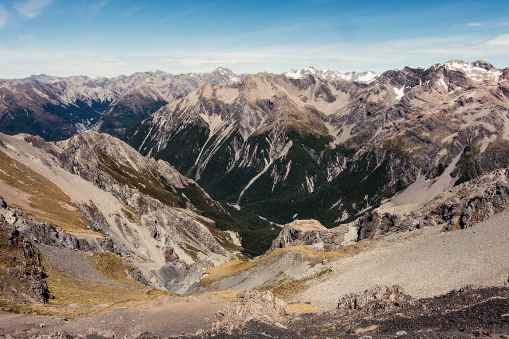
Tame, brushy valley sides topped by staggering peaks surround the tiny alpine village of Arthur’s Pass in the heart of national park at 739m.
what to expect.
Arguably the best journey (drive and train ride) to be had in the whole of New Zealand: The Great Alpine Highway (State Highway 73) or TranzAlpine train ride
Mountainous terrain cloaked in native bush and beech forest and traversed by wide, untouched riverbeds like the beautiful braided Waimakariri River along the Great Alpine Highway as it climbs steadily towards Arthur’s Pass
The Avalanche Peak Track, one of the country’s best day hikes with 360-degree panoramic views of the Southern Alps
Tame, brushy valley sides topped by staggering peaks surround the tiny alpine village of Arthur’s Pass in the heart of national park at 739m
One of the world’s greatest scenic train journeys, the TranzAlpine railway that connects Greymouth and Christchurch by traversing the Southern Alps via Arthur’s Pass and covers 223 kilometres in just under 5 hours
location & park information.
Where & getting there: ‘Arthur’s Pass’ refers to three places at once: Arthur’s Pass National Park located on the Main Divide of the Southern Alps; the pass itself, the highest across the Southern Alps; and Arthur’s Pass village, situated five kilometres south of the pass towards Christchurch. Despite the remoteness at high altitude, there are several ways you can travel to Arthur’s Pass. The easiest is probably driving on the Great Alpine Highway (SH73) that connects the East and West coast via the Southern Alps. It passes through Arthur’s Pass and is one of the most beautiful scenic drives in the world. Several bus companies also provide daily shuttle services in and out of the park (East West Coaches, Atomic Travel, InterCity). The most relaxing way to travel across the pass, however, is on the TranzAlpine train that runs between Greymouth on the East Coast and Christchurch. This is one of the world’s greatest scenic train journeys and a must-do on every New Zealand itinerary.
Where to stay: The Nook, Arthur’s Pass Motel & Lodge
Where to eat: it’s easiest to bring your own food, options for eating in Arthur’s Pass village are few and the store only stocks some basic, overpriced groceries
When to go: summer (November – March); note that this is an alpine region prone to sudden weather changes at any time of the year. Especially on the peaks and saddles at higher altitudes it is often surprisingly windy and cold.
How to get around: by car, there’s no local public transport; if you stay in the village itself, you can also easily walk everywhere
Stop & Explore: Castle Hill Conservation Area, 90km northwest of Christchurch. A short 10-minute walk from a roadside carpark are hundreds of smooth, sculpted limestone formations scattered across parched grassland. You might recognize the scenery from battle scenes of The Chronicles of Narnia: The Lion, the Witch and the Wardrobe that were filmed here.
How to prepare: if you intend to stay overnight in high season, book accommodation well in advance as there are few options; buy all food on your way to Arthur’s Pass
Further reading: Official DOC information about Arthur’s Pass
Drive | 245km | 3.5 hours travel time
The Great Alpine Highway
The Great Alpine Highway is one of New Zealand’s most beautiful scenic routes and on its traverse of the Southern Alps takes in an incredible variety of scenery.
We started the 245km journey in Christchurch on the East Coast of the South Island and traveled west across the flat expanse of the Canterbury Plains. This green patchwork quilt of fertile meadows and pastures produces 80% of the country’s grains and seeds and stretches from the Pacific Ocean to the mountains inland, which grew ever larger as we approached Springfield on the western fringe of the plains. Once we’d passed through this little township, paddocks transitioned smoothly into tussock and beech as the highway slowly climbed into the foothills of the Southern Alps to Porter’s Pass and into a succession of steep-sided valleys rising to snow-capped peaks.
Unintentionally we traveled at the time of day, late in the afternoon, when the landscape was most beautiful as the light grew soft and smothered everything in golden hues. There was surprisingly little traffic, even at Castle Hill, where the mighty Craigieburn and Torlesse mountain ranges rise to the left and right and the road passes by a battle scenes location of The Chronicles of Narnia: The Lion, the Witch and the Wardrobe with enormous monolithic limestone rock formations.
Judging by the size of the deserted car park this place gets quite busy, but we walked among the giant weathered boulders and their long shadows scattered across the field and met no one as the setting sun spilled through one perfectly curved rocky archway like an orange spotlight onto the parched grassland.
It’s a terrific, mystical place that I thought would be impossible to top, until the road started to travel alongside the braided Waimakariri River and then across the wide, wild river bed. I have seen only few places that convey unspoilt nature better than the narrow branches of this river flowing every which way it pleases on the vast expanse of white pebbles. Both, Castle Hill and the Waimakariri River, deserve lengthy stops.
North of the Waimakariri River, the road follows the Bealey River upstream through a glacial U-shaped valley to Arthur’s Pass village in Arthur’s Pass National Park.
While the glaciers shaping this landscape have long since retreated to some small specks of ice clinging to higher peaks, the stunning natural legacy they left behind became the South Island’s first National Park in 1929. Over time, large areas of the park were made accessible by some fantastic hiking trails, but not many are suitable for less experienced hikers.
At least that is my impression when I read through the DOC information about Arthur’s Pass and wondered how many people needed to be rescued there every year. It must be many. The DOC is rarely that reserved in promoting hiking and seldom admits to not developing tracks to their usual high standard. People with little or no backcountry experience and skills are clearly advised to go elsewhere. But despite the strong warnings, we met hikers on the Avalanche Peak Track, who would have better heeded that advice. There are some easier options if not many, one of them is the 45-min Devil’s Punchbowl Track.
After two days in Arthur’s Pass village and some great hiking in the national park, we followed the road to the actual pass at 920m altitude and across the Otira Viaduct winding gracefully through the steep and narrow Otira Gorge high above the valley floor down towards the West Coast.
With every passing minute, the vegetation in the gorge changed, became denser, more lavish, and varied with abundant lichen and moss. Soon, a mix podocarp rainforest with magnificent tree ferns and red-flowering rata rose up the steep mountain face.
The differences in vegetation between the two coasts so striking, I looked up the annual rainfall in Hokitika (6519mm) and Christchurch (843mm) and wondered just how we managed to pick a week for the West Coast Wilderness Trail with no rain predicted for Hokitika and Greymouth.


At Castle Hill, where the mighty Craigieburn and Torlesse mountain ranges rise to the left and right, the road passes by a battle scenes location of The Chronicles of Narnia: The Lion, the Witch and the Wardrobe with enormous monolithic limestone rock formations.
Hike | Loop trail | 4-6 hours
Avalanche Peak Trail
Hike | Out & back trail | 3-5 hours
Bealey Spur Track
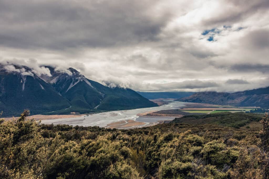
The braided Waimakariri River flowing every which way it pleases on the vast expanse of white pebbles.
Walk | Out & back trail | 30-45 minutes
Devil's Punchbowl Walking Track
One of the few gentle short walks in Arthur’s Pass village is Devil’s Punchbowl Walking Track to a wooden viewing platform at the bottom of 131m-high Devil’s Punchbowl waterfall.
We had just watched the falls plummet down the steep mountain face from the opposite side of Bealey Valley on the Avalanche Peak Track and were keen to take a closer look, when we realized that the two tracks, Avalanche Peak and Devil’s Punchbowl, conveniently start and end just across the road from each. So, we decided quite spontaneously to do both in one go and added Devil’s Punchbowl as a lovely, easy finish to our hike in rough backcountry terrain.
And ‘easy’ it is – a gentle stroll through beech forest, on wooden boardwalks mostly, up some stairs, and across two bridges spanning the Bealey River and Devils Punchbowl Creek. At the end of the trail, there’s a small viewing platform and gazing up at the torrents of water plunging noisily down the dark rock face, I was surprised how different my impression of the waterfall was from up close.
From the distance, the size of the waterfall in its entirety had already been impressive. Yet up close, the amounts of water crashing heavily into the ‘punchbowl’ rock pool below were fascinating, almost intimidating.
We met few people walking to the waterfall and back and had the viewing platform to ourselves, but I imagine it’ll be much busier once international tourists are back. In any case, it pays to go after midday when the falls are no longer in the mountains’ shadow.
track details.
Start/End: Punchbowl car park, off SH73 at the northern end of Arthur’s Pass village
Directions: from Arthur’s Pass Visitors Centre, head north on SH73 for 500m and turn right into Punchbowl Road. The car park is signposted off the highway.
Distance: 2km return
Time: 30-45min return (official DOC estimate: 1 hour return)
Elevation gain: +/- 100m
Difficulty: easy
Best time to walk: any time after midday because in the mornings, the falls are in the mountains’ shadow
Permits: none required
Further information: Official DOC information


