Hike | Nelson Lakes NP | New Zealand
Discover the best hikes in Nelson Lakes National Park
Text | Anninka Kraus
Photography | Tobias Kraus

New Zealand Tasman
Nelson Lakes National Park, established in 1956, is situated at the northernmost end of the Southern Alps, a mountain range running much of the length of the South Island, and sits on the Alpine Fault where continental collision has thrust up towering mountain ranges.
The name of the national park however refers to its two large glacier-carved alpine lakes – Lake Rotoiti and Lake Rotoroa. Hanging, U-shaped valleys, their steep, rugged rock face cloaked in dense beech forest, and carved out hollows turned into tarns now dotting the alpine landscape, scree slopes, and moraine terraces are further testimony to glaciation during the last ice age.
Underneath the beech tree canopy, the valley floor is strewn with tiny beech leaves, and fern and spongy moss cushions thrive into a thick, impenetrable curtain of greenery.
The green canvas is a dappled, bountiful palette of delicate tones and only the blackened trunks of the beech trees appear foreign in colour. We first thought the charcoaled-coloured bark may be the testimony of a recent bush fire, but this is not the case at Nelson Lakes. It’s sooty mould. Small insects, buried in the bark, feed on the tree’s sapwood and secret surplus ‘honeydew’ through a thin tube. Birds and other insects feed on the tiny droplets gleaming at the end of white hair-thin strands and so does mould. On the Honeydew Walk you’ll see this phenomenon clearly.
At lower elevations, red beech is predominant but gives way to silver beech with increasing altitude and in turn mountain beech that becomes dwarfed approaching the almost linear tree line.
This line distinctly divides the mountainsides into dense, dark greenery below 1400m and pale straw-coloured tussock and sub-alpine shrubs above, that persevere, until they too concede to barren rock.
jump ahead.


Impressive views of the lake, village, and surrounding mountains from Parachute Rocks on the St Arnaud Range Track.
what to expect.
Stunning lake panoramas against the backdrop of the northernmost mountain ranges of the Southern Alps
Marvelous deep solitude in what I believe may be New Zealand’s most underrated national park
A variety of short walks, half- and full-day hikes, and multi-day backcountry tramping trails maintained by the DOC that showcase the park’s pristine alpine wilderness
Tranquil beech forest that changes with altitude: red beech at a lower elevation gives way to silver beech which in turn is replaced with dwarfed mountain beech
Nelson Lakes National Park does not feature a Great Walk (yet) and receives very little attention from both domestic and international travelers. Even on a fine summer weekend there’s never much of a crowd, and hardly any thru-traffic.
From our holiday home with stunning views across Lake Rotoiti to Mt Robert and the St Arnaud Range, we also had a glimpse of the (only) road passing through St Arnaud, a tiny village on the shores of Lake Rotoiti and gateway to the park.
Watching the sunset, we noticed that for 15, maybe 20 minutes at a time, not a single car passed. After touring New Zealand for months we’ve not yet found another town with road access inside a national park as sleepy as St Arnaud. The tranquility is reason in itself to visit.
Even without a Great Walk, Nelson Lakes is still renowned for excellent hiking. Kerr and West bays at St Arnaud on Lake Rotoiti and the carpark and jetty at the northern end of Lake Rotoroa are the starting point for several gentle, shorter walks, many of which can be linked to make for a longer walk and showcase the mountain-lake panorama, beech forest with its muffled sounds and inquisitive small birds, and serene lakeshore. Of the two lakes, Lake Rotoiti is more accessible and popular and slightly less sandfly-ridden.
There are also several half- and full-day hikes in the park, including Mount Robert Circuit (2:30-4 hours return, 7.5km), St Arnaud Range Track to Parachute Rock (3-4 hours return, 12km), and Lake Rotoiti Circuit (5-7 hours, 23km). All three are easy to intermediate walks that require no backcountry skills but moderate hiking experience (easy river crossings, significant changes in altitude, tracks may be unformed with rough or steep sections).
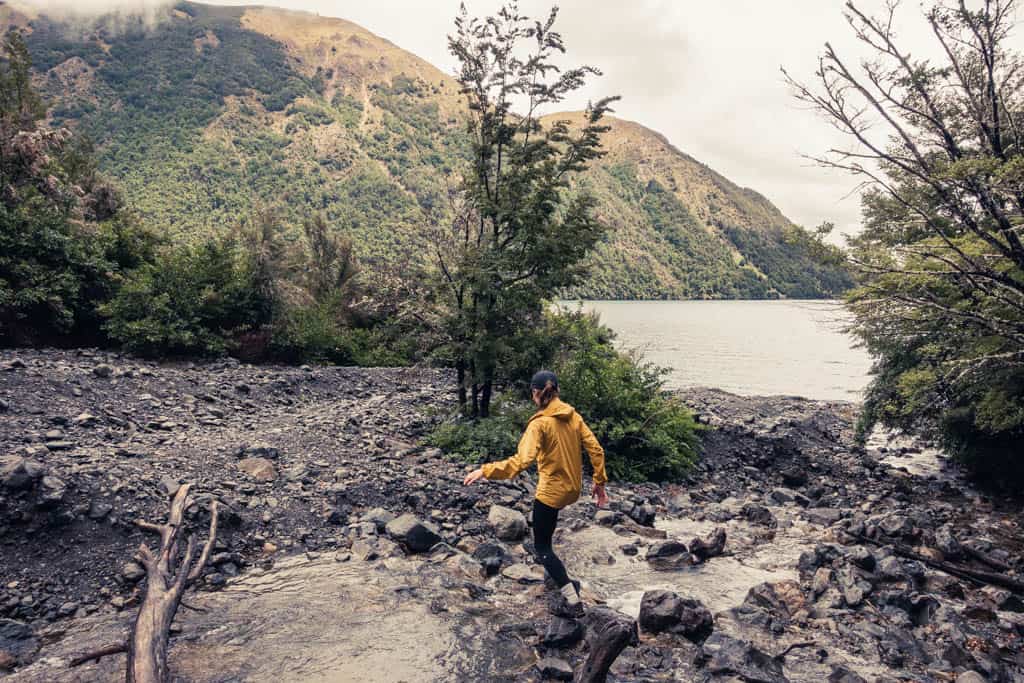
We also hiked the Travers-Sabine Circuit, a multi-day backcountry tramp, including a side trip to Blue Lake. This track is one of the popular alternatives to the Great Walks and in parts shared with the Te Araroa long-distance trail.
The accounts and images of the park are altogether glorious (with the exception of the odd sandfly horror story) – Lake Rotoiti idyllically encroached upon by the St Arnaud Range and Mt Robert – and totally different to my own recollections of a school trip to the Outward Bound Education Center at St Arnaud from twenty years ago: After getting no sleep in the noisy bunk room, I reluctantly slip into itchy, reeking polyprops that aren’t mine but I had to hire to keep somewhat warm because at Lake Rotoiti, from what I remember, it is always freezing cold and the only temporary reprieve from the chill are watery hot chocolate and canned baked beans on toast for breakfast.
I think, the worst is over, but after scrubbing tomato sauce off 50 plates, we are made to hike, in the mud, cross rivers and sleep under a tarp (feet still wet) with possums trampolining on us in the middle of the night. I thought of this place as a ‘once-in-a-lifetime’-experience never to be repeated.
Obviously, my recollections were somewhat skewed, and I thought that maybe I should give it another try. This time, I took my own icebreaker gear, stocked up on thick sliced toast and granola for breakfast and booked a lavish holiday home, with an indoor fireplace; it’s midsummer, but just in case – and voilà. I loved our stay at the Lakes!
But also, we found out that visiting mid-January is no guarantee for high temperatures and sunshine. When the DOC warns that freezing conditions in alpine areas may occur at any time of the year, take their word for it! Following a day with temperatures in the high twenties, we suddenly encountered single digit temperatures with wind chill and hail on the ridge the next morning and hikers crossing Travers Saddle that day walked through freshly fallen snow.
Interestingly enough, sandflies, the ever-present torturing, blood-hungry beasts flocking to the lakeshores, aren’t put off by the cold and I finally believe my mum who claims she was bitten here in winter, the pebble beach white with hoarfrost. Strong wind is your best friend when it comes to sandflies, and copious amounts of DEED of course. Also, sandflies have difficulty keeping up with moving objects, so, if all else fails, run.


At Whisky Falls – named after an illicit whisky still discovered here in the 1880s – the water plummets vertically down a thickly covered moss overhang for 40 meters before cascading into several rock pools.
location & park information.
Where & getting there: St Arnaud is 1:30 hours from Nelson and Blenheim, 2 hours from Westport and 5 hours from Christchurch. | The easiest way of getting to Nelson Lakes National Park is by car. At the time of our visit with borders closed and few international visitors around, there was no public transport between Nelson and St Arnaud. Another option is private shuttle companies that mainly provide transport to well-known trails in the region. Nelson Lakes Shuttles provides scheduled and chartered services between Nelson and St Arnaud and to other trails in the area, such as the Heaphy Track and Abel Tasman Track.
Where to stay: Accommodation options are few and mainly consist of airbnbs, the Alpine Lodge and Backpackers and DOC operated campsites at Kerr Bay and West Bay.
Where to eat: There’s only one restaurant that our host felt comfortable recommending, at the lodge, and a petrol station stocking the essentials. If you can, bring all your food with you. | The closest town with a small FourSquare supermarket and bigger choice of restaurants is Murchison, 40 min by car, but it’s easier to buy food and supplies in Nelson.
How to get around: St Arnaud is small enough to walk everywhere | Hamish operates a water taxi on Lake Rotoiti all year around (St Arnaud to Lakehead Hut or Coldwater Hut $30 pp) and also hires out kayaks; phone: 021 702 278
How to prepare: Buy all food on your way to Nelson Lakes | The park is administered by the DOC, who operate the Rotoiti/Nelson Lakes Visitors Centre and help with reliable information about hikes and walks in the area.
Even the ghostly atmosphere on a rainy day with dirty skies and thick mist wafting across the beech tree crowns suits Nelson Lakes very well.
Hike | Loop trail | 1-2 days
Lake Rotoiti Circuit
The name of this track is all too apt; starting at Kerr Bay in St Arnaud, the trail circles the entire lake, a depression hollowed out by Travers Glacier and fed by the Travers River. The circuit can be hiked in either direction and will take between 5-7 hours (crossing the Travers River between Lakehead Hut and Coldwater Hut) and 7-10 hours (going via a swing bridge north of Lakehead Hut, adding approx. 3 hours to the walk) to complete.
Hike | Out & back trail | 3-4 hours
St Arnaud Range Track & Honeydew Walk
The St Arnaud Range Track starts at the far end of Kerr Bay, near Hamish’s water taxi caravan office, and zigzags steeply through beech forest to Parachute Rocks at 1400m, just above the bushline. As we climb higher, red beech gives way to silver beech and eventually dwarfed mountain beech takes over as the forest thins with altitude gain.
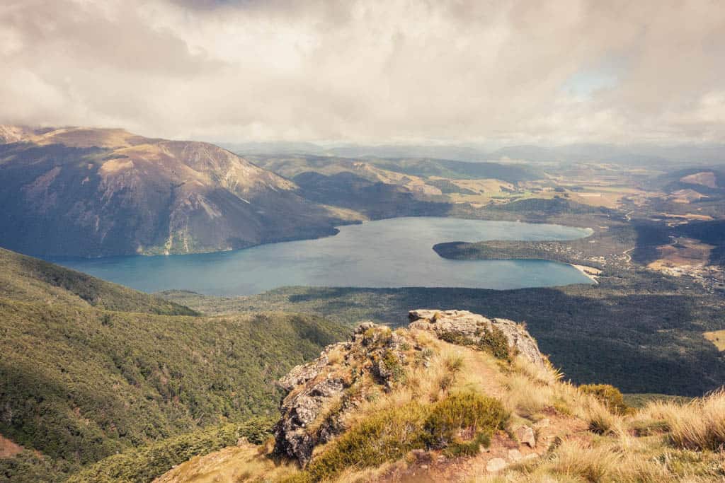
Stunning lake panoramas against the backdrop of the northernmost mountain ranges of the Southern Alps.
Walk | Loop trail | 3-4 hours
Mt Robert Circuit
Mount Robert Circuit joins two tracks – Pinchgut and Paddy’s – into a loop track that traverses the northern face of Mount Robert. As a result of the devastating loss of trees by fire in 1887 and subsequent use as farmland, the ridge top and northern slopes are barren and allow spectacular views over Lake Rotoiti, St Arnaud, and the surrounding mountains for much of the way.
We set out anticlockwise on the Pinchgut Track as it climbs in zigzags up the steep northern slope of Mt Robert, weaving in and out of beech forest, and emerges above the tree line on the western ridgeline. After gaining the ridge, the trail flattens out across the mountaintop covered in red tussock and sub-alpine shrubs and arrives at Relax Shelter and a junction with Paddy’s Track. If you were to continue south on the Pinchgut, the track would eventually meet the Robert Ridge Route to Angelus Hut.
Traversing the exposed ridge is a far more challenging hike however than Paddy’s Track cutting east across the open ridge top and down to Bushline Hut (1280m). On the descent back to Mt Robert car park, the views are still spectacular and the track turns into a well-defined gravel path, much too tempting not to break into a run down the homestretch.
track details.
Start/End: Mt Robert carpark
Route: Mt Robert carpark – Pinchgut Track – Relax Shelter – Paddy’s Track – Bushline Hut – Mt Robert carpark / our recommendation is to walk the Mount Robert Circuit anticlockwise – uphill on the steep switchbacks on the Pinchgut Track and downhill on the easier Paddy’s Track
Distance: 7.5km
Time: 2:30-4 hours – official DOC estimate 5 hours
Elevation: 630 meters (+/-)
Difficulty: easy, but exposed to the weather
Options: suitable for trail running
Permits: none
Further information: Official DOC information
Hike | Loop trail | 4 days
Travers-Sabine Circuit
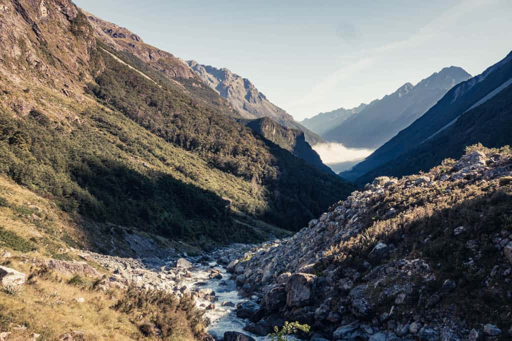
The Travers-Sabine Circuit is often described as a popular yet less crowded alternative to New Zealand’s Great Walks. The scenery is one of varied alpine wilderness: two river valleys – Traverse and Sabine – are densely cloaked in greenery and furrowed by alpine rivers, unbridged streams, and steep gullies.
Separating the two valleys is Travers Saddle, an alpine pass at almost 1800m, with wide, slippery scree slopes running down either side.