Hike | Arthur's Pass | New Zealand
Hiking the Avalanche Peak Track in Arthur's Pass
Text | Anninka Kraus
Photography | Tobias Kraus

New Zealand Canterbury
Avalanche Peak at 1833m is the only summit in Arthur’s Pass marked by a poled route to the top. Two routes, in fact, Avalanche Peak Route and Scotts Route, that can be joined into a loop track.
Both are tracks (challenging hiking track suitable for people with moderate to high-level backcountry skills) to the bushline at 1200m. Beyond that they become routes.
That means you should be comfortable in hazardous terrain on a track that is recognizable as such only by cairns and snow poles placed at regular intervals and requires complete self-sufficiency. If this is outside your comfort zone, don’t go. There have been several fatalities on the peak and the warnings from the DOC – ‘Dying to see the view?’ – could not be more direct.
We faced a chilly 6 degrees and bright blue skies as we walked from our accommodation to the Avalanche Peak Track trailhead just behind the original visitor centre. Arthur’s Pass is that small, walkable.
Then we started climbing up, following the track in a clockwise direction, because the terrain and gradients favour the Avalanche Peak Track on the ascent and Scotts Route on the descent. Which is a nice way of saying that the ascent through mountain beech forest is a particularly steep, rocky, and relentless climb up the south side of Avalanche Creek.
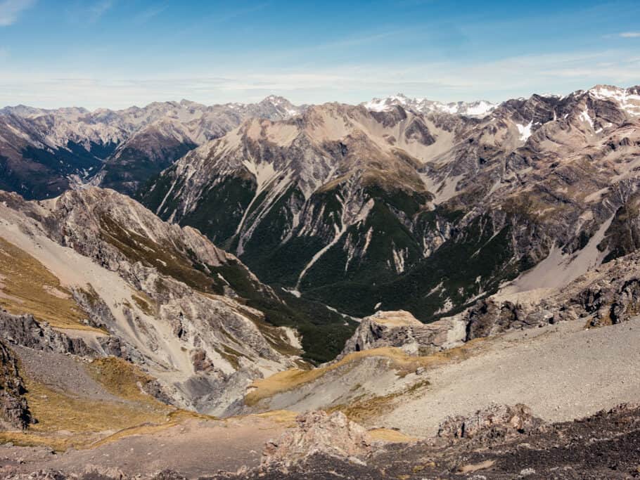
When the beech finally cleared, a short, trampled path forked off from the main route towards the exposed mountain face with amazing views down the Bealey Valley. Take extra care here, especially in bad weather – this is a backcountry route and no warning sign or railing stops you from wandering straight off the vertical cliff into the ravine.
On a fine day, the track was easy enough to follow along the line of yellow markers dotted across the tussock-covered ridge and didn’t require much technical skill. Not to start with anyway. The difficult part came later, when snow tussock and subalpine shrubs had given way to barren rock and the trail traversed large boulders and slippery scree.
Minutes short of the small summit plateau, the exposed ridge narrowed to a few handbreadths in width with sheer bluffs on either side. This is the most challenging trail section but also the most rewarding: from the peak, the 360-degree panoramic views over the jagged skyline of the Southern Alps, dominated by Mt Rolleston at 2271m rising to the north-west with Crow Glacier on its southern side, are arguably some of the best in New Zealand.
You can return to Arthur’s Pass on the Avalanche Peak Track, or, like us, follow Scotts Route forking off to the north-east, ten minutes down from the saddle. This route is equally well marked, with orange poles, and makes for a nice round trip.
The familiar scramble across broken rock soon transitioned into a well-defined track across an alpine grassland plateau with fantastic views of Devil’s Punchbowl waterfall on the opposite side of Bealey Valley. After the track met the bushline again, it wound down the south side of McGrath Creek to the trail end 700m up from Arthur’s Pass Visitor Centre, directly vis-à-vis Devil’s Punchbowl Falls Track.
Avalanche Peak Track may be challenging and not suitable for people with limited hiking skills and experience, but the track easily made it into our list of New Zealand’s top 10 day hikes.
related


Tame, brushy valley sides topped by staggering peaks surround the tiny alpine village of Arthur’s Pass in the heart of national park at 739m.
Arthur's Pass | New Zealand
Hike | Loop trail | 4-8 hours
track details.
Start: Arthur’s Pass village, behind Visitor Centre on SH7
End: SH73 opposite Devils Punchbowl Falls in Arthur’s Pass village, 500m north of Visitor Centre
Route: Arthur’s Pass Visitor Centre – follow orange markers on Avalanche Peak Track – Avalanche Peak summit at 1833m) – follow yellow markers on Scotts Route – SH73 opposite Devils Punchbowl Falls in Arthur’s Pass village
Distance: 6.8km
Time: 4 hours (official DOC estimate: 6-8 hours)
Elevation gain: +/- 1080m (lowest point: 740m / highest point: 1833m)
Difficulty: moderate-difficult (Official DOC grading: Expert Route); suitable for people with previous backcountry skills and experience in remote areas; do not attempt this track in high winds, poor visibility, or if there’s ice/snow and keep to the track at all times; prepare well in any case, because the weather is subject to frequent and sudden change
Best time to hike: summer, autumn
Permits: none required
Further information: Official DOC information
