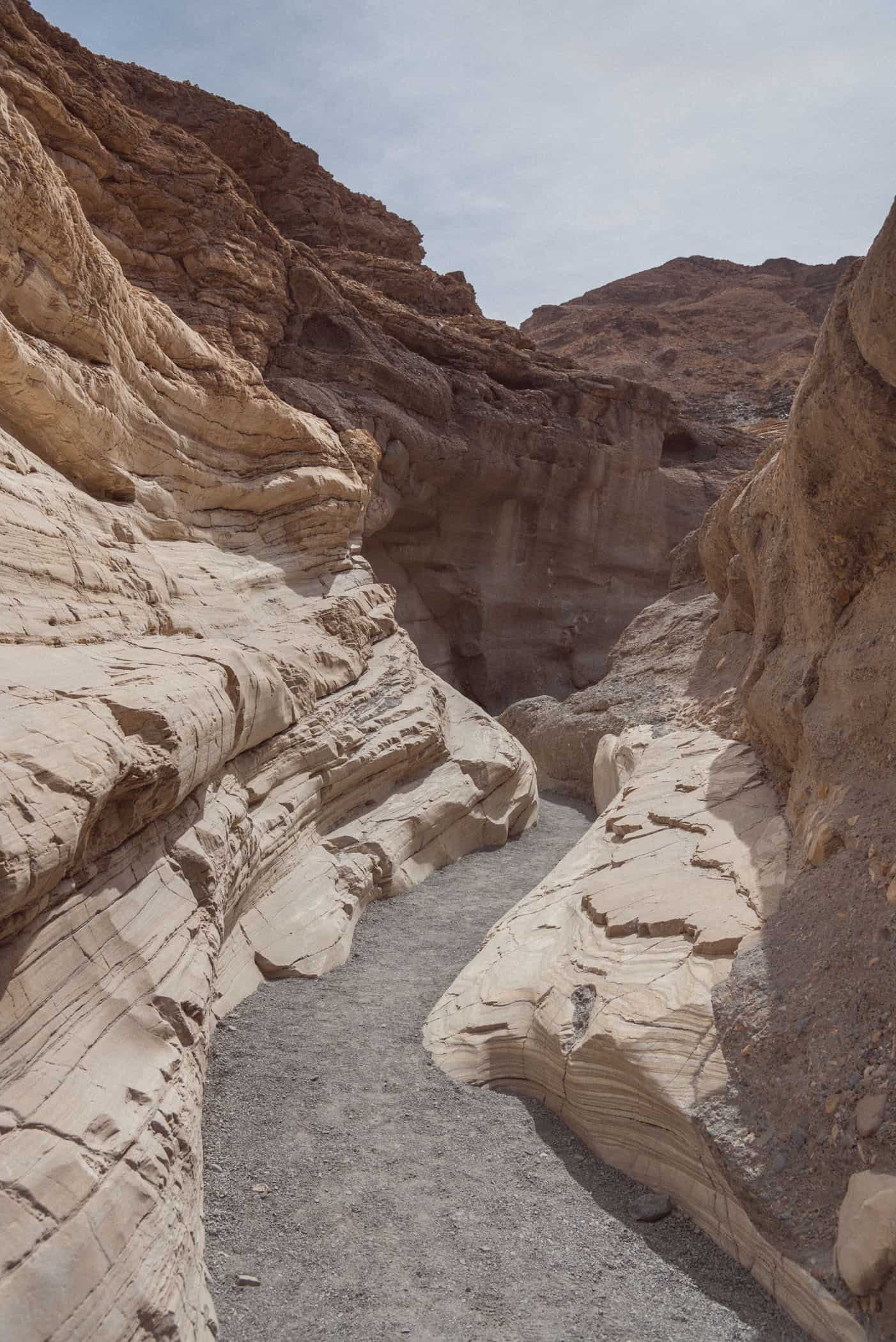
Mosaic Canyon is a narrow slot canyon in Death Valley National Park with stunning narrows made of smooth marble walls and mosaic "breccia".

After many months of traveling across the vast Australian outback, we thought we had discovered the most desolate of wastelands. A wilderness so isolated and inhospitable, we seemed to be in a different world altogether, on Mars maybe, but certainly not Planet Earth.
But when we visited Death Valley in Eastern California, we discovered the most forbidding world yet. Still hotter, drier, and more desolate than any other place we’ve ever visited. Among the first to experience this harsh environment were pioneers who got lost in the desert valley on their way to the California goldfields in the winter of 1849-1850 and gave the valley its ominous name.
Years later, in 1913, a temperature of 57°C was recorded in Furnace Creek, the highest temperature ever recorded. The geographical location of the park in the northern Mojave Desert, hemmed in by the Panamint Mountains to the west and the Amargosa Range to the east and characteristic desert climate make Death Valley at once the hottest and one of the driest places on earth.
You’d think that no earthly creature could withstand the ferociously hot daytime heat in summer and extreme dryness. But the desert is very much alive, day and night, and supports surprisingly rich biodiversity. The more time we spent exploring Death Valley’s narrow canyons and characteristic badlands, the more we noticed lizards skittering between rocks, squirrels chasing each other up the juniper trees, and ravens circling above the campground waiting to wreak havoc on someone’s site (better not to leave anything outside, especially food).
Much bigger creatures still, bighorn sheep, coyotes, and kit fox, have adapted to the harsh conditions of the desert, although we did not see any.
The most common scenery in the park, however, is bare rock, devoid of almost any vegetation. It was quite astonishing really, how that lack of greenery puts a particular focus on the beautifully carved and colored rock formations rising against a bright blue sky and snowcapped mountains.
At night, when the incredible emptiness of the valley is amplified by the high and exceptionally dark and starry skies, the softest of sounds travel easily across this silent expanse.
Death Valley is easily accessible by car and being able to see grand panoramas, narrow slot canyons, salt-encrusted plains, and wavy sand dunes, from the comfort of your airconditioned car is certainly a great advantage during the hotter months. Artists Drive, the park’s most spectacular scenic drive through the Amargosa Range foothills, is a stunning and very comfortable adventure.
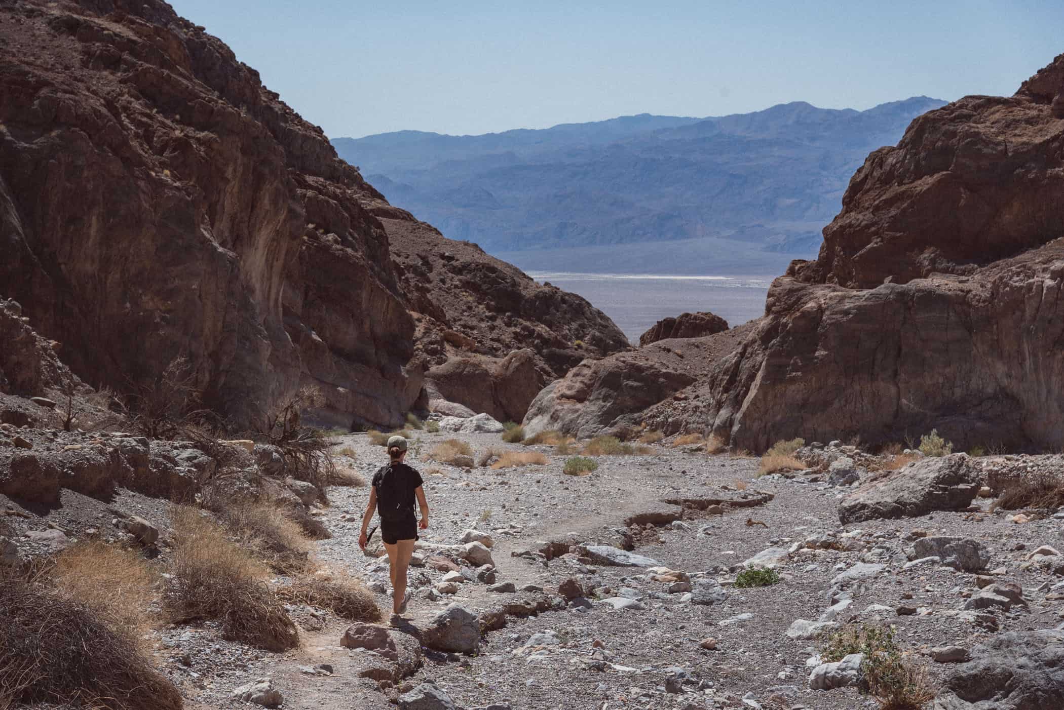
I’d still encourage you to explore some of the park’s many popular and well-maintained scenic walking tracks. Not in the extreme midday heat, of course, but our morning and evening hikes became our fondest memories of Death Valley. The trails range in walking distance, time, and difficulty from short strolls that access the park’s most spectacular viewpoints to unmarked backcountry routes.
We’ll share our 5 favorite trails in Death Valley National Park in this post, but if you need more help finding a walk or hike to suit your experience and ability, we found the staff at the visitor center to be really friendly and helpful.
When you plan your visit, it helps to know that the park is really huge, and 90% of it is a designated wilderness area, not easily accessible. The Furnace Creek Area is Death Valley’s central hub, where you’ll find lodging, restaurants, the park’s main visitor center, a post office, and a small general store. It’s located roughly in the center of the park with Golden Canyon Trail, Zabriskie Point, Artists Drive with Artists Palette and Badwater Basin in easy reach.
Thirty minutes northwest of Furnace Creek on CA 190 is Stovepipe Wells Village, the second tiny desert community in the park near two of its main attractions, Mosaic Canyon and Mesquite Flat Sand Dunes. The northern section of the national park, the area around Scotty’s Castle and Ubehebe Crater, was temporarily closed due to flood damage at the time of our visit.
1. Mosaic Canyon Trail
Hike | Out & back trail | 2-3 hours
Walk | Out & back trail | 10-20 min
3. Fall Canyon
Hike | Out & back trail | 3-5 hours
4. Badwater Basin
Walk | Out & back trail | 10 min +
5. Golden Canyon, Gower Gulch & Badlands Trail
Hike | Loop trail | 2-3 hours


An isolated and inhospitable yet stunningly beautiful wilderness
The hottest and one of the driest places on earth
Grand panoramas, narrow slot canyons, salt-encrusted plains, and wavy sand dunes grand panoramas, narrow slot canyons, salt-encrusted plains, and wavy sand dunes
A large network of popular and well-maintained scenic walking tracks through the desert
Directions: Death Valley National Park lies in southeastern California, two hours east of Las Vegas. The two paved highways that travel through the park are CA 190 (east-west) and CA 178, also referred to as North Highway and Badwater Road (south-north). You can also enter the park on SR 374 from Beatty in the east, but SR 267 was closed until further notice at the time of our visit.
Best time to visit: The best time to visit Death Valley is from late autumn to early spring, between November and March when daytime temperatures are reasonably pleasant. I would advise against a visit in summer when the extreme heat makes any outdoor activity almost unbearable.
Plan your visit: The entrance fee is $30 per vehicle for 7 days unless you have the annual America the Beautiful Pass ($80/1 year/2 pass owners), which covers entrance fees at all national parks and many other recreational areas in the States. Unlike most other national parks, there are no fee gates as you enter Death Valley. Pay park fees at Furnace Creek Visitor Center or self-pay machines.
Camping in Death Valley National Park: The largest national park service campground in Death Valley is Furnace Creek (open all year; incl. 18 full hookup sites; make reservations well in advance!). If you’ve missed out on securing a spot at Furnace Creek, you’ll almost certainly have more luck at another of the campgrounds run by the park (most are first-come, first-serve) or the privately-operated campgrounds at The Ranch, Stovepipe Wells, and Panamint Springs.
Unfortunately, the park doesn’t operate a single shower facility. That’s a huge drawback in this climate, in my opinion, and the reason is not a lack of water apparently, as the park staff simply tell you to purchase a $14 pass for the pool and showers at The Ranch, per person. If you don’t want to use the pool and only need 5 minutes in the shower, you’ll still have to buy the pass. That was one very expensive 5-minute shower, and I feel for any family with two or three kids wanting to take a shower after a hot and exhausting day hiking in Death Valley.
Water: Because Death Valley is exceptionally hot and dry, you’ll need to drink more water than usual, especially on hikes. The official guideline is to drink at least one gallon (4 liters) of water per day and more if you are active.
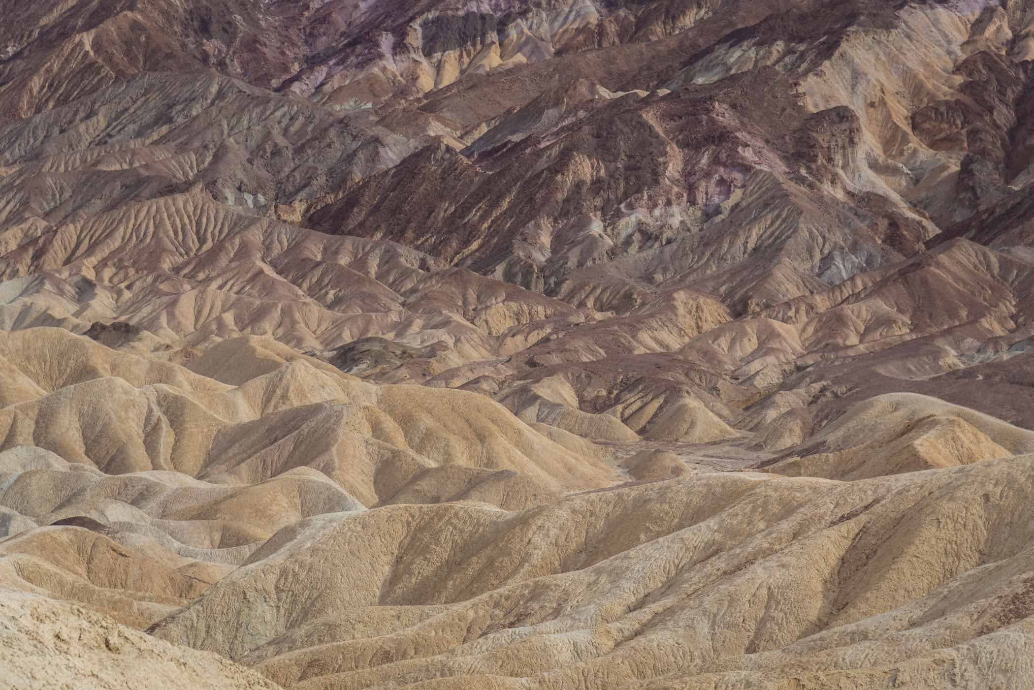
As one of Death Valley’s most iconic viewpoints, Zabriskie Point is a must-visit location for watching sunrise and sunset in the park. In the changing light of dawn and dusk, the stripped hills of the badlands glow in yellow and brown shades against the backdrop of prominent Manly Beacon outcrop and intense alpenglow on the distant Panamint Mountains.
From Furnace Creek Visitor Center, head east on Highway 190 for about ten minutes until you see a sign for Zabriskie Point and a large parking lot coming up on your right. You’ll see a paved walkway running up a small hill and a large crowd milling around the 360-degree viewing area at the top.
That’s Zabriskie Point, a short 400m walk up the accessible paved walkway from the parking lot. Before you start up the hill, you’ll see a hiking trail forking off to the right. That’s the start of the 4.3km Badlands Loop Trail which connects with the Golden Canyon, Gower Gulch, and Red Cathedral trails and is a wonderful option for those keen to explore the maze of colorful badlands scenery.


Hear the salt crust crack at Badwater Basin
Badwater Basin, at 86m below sea level, is the lowest point in North America and is wonderful to visit at sunrise or sunset. The dry, cracked crust of the salt flats stretches across 500 square kilometers where once an inland lake covered the valley and is one of Death Valley’s most unique and fascinating features.
Park at the large car park off Badwater Road, at the edge of the salt flat, 30 minutes south of the Furnace Creek Visitor Center, and walk out onto the vast flat expanse for as long as you like. There’s no designated trail once you’ve passed a small spring-fed pool at the start, but a wide, well-trodden path leads out onto the plain to where you’ll likely see quite a few people milling around, taking photos. You can spend ten minutes or hours walking across the salt deposits, it’s completely up to you. I strongly recommend timing your visit around sunrise or sunset though, because the basin appears very different in the changing colors and soft light.


Please note that trail conditions may have changed since we published this post. For your safety, please verify trail status and conditions on official websites before your trip.