Following in the steps of copper miners, who built the Grandview Trail in 1892-93, this brilliant hike will venture deep into the Grand Canyon.

In northern Arizona, a giant, rugged scar in the surface of the earth draws millions of visitors every year – the Grand Canyon. The gulf slicing through the Colorado Plateau is so prominent, in fact, it’s visible from space. And yet, as we walked down a small trodden footpath at Desert View Campground to what our camp host promised would be the best viewpoint on the South Rim (which it is!), there was no change in the landscape of pinyon, ponderosa pine, and juniper trees alerting us to the abyss ahead.
We were mere steps from the edge of an almost vertical cliff when this vast chasm, 10 miles wide (16km), suddenly opened up at our feet. It’s a spectacular sight – even if you’ve seen your fair share of impressive gorges and canyons, I promise you’ll still be blown away by the sheer size and beauty of the Grand Canyon.
A large section of the canyon is protected as a national park – one of the most popular in the US – and a designated World Heritage Site. The canyon was also voted one of the 7 Natural Wonders of the world, and looking at its spectacular copper-colored scenery of buttes, sheer cliffs, and flat-topped mesas that were created by the tireless erosive force of wind and water, it’s easy to see why. Splashing color on the barren rock are pockets of greenery scattered across the canyon, like the springs at Bright Angel Campground and Phantom Ranch, which you can spot from the South Rim Walk.
The trail runs right along the edge of the cliffs and allows magnificent views over the canyon and across to the North Rim for the entire 13 miles (21 km) trail distance between South Kaibab Trailhead and Hermits Rest. Try to time the finish of your walk with sunset, when golden light floods the canyon and paints the rock in various shades of fiery reds.
More challenging trails descend into the canyon past different-colored horizontal layers of sandstone, limestone, and shale, which are usually hidden below the earth’s crust. To gaze up at the vertical canyon walls is absolutely thrilling, and I highly recommend walking below the rim even if it’s just a short way down the easiest of the canyon trails, the Bright Angel Trail.
This is where my fascination with the Grand Canyon really comes alive, and the features attesting to its 6 million-year-old history are most visible, like the ancient rock layers and obvious signs of continuing erosion. The further you descend into the canyon, the closer you’ll also get to the slow-moving, gently curving ribbon of greenish water at the bottom of the canyon that is the Colorado River and has helped carve this spectacular chasm.
1. South Kaibab-Tonto-Bright Angel Loop Trail
Hike | Loop trail | 5-8 hours
2. Grandview-Tonto-Hance Creek Loop Trail
Hike | Loop trail | 5-8 hours


One of the most popular National Parks in the United States, a designated World Hertiage Site, and one of the 7 Natural Wonders of the world
A spectacular scenery of buttes, sheer cliffs, and flat-topped mesas that were created by the tireless erosive force of wind and water
Great tourism infrastructure and facilities for campers
A great mix of easy walks along the rim and more challenging trails that descend below the rim and venture deep into the canyon
Should you visit the South Rim or North Rim? Obviously, the canyon has two rims, the South Rim and the North Rim, separated by a chasm up to 18 miles wide (29 km) and 1000 feet (300m) elevation difference. First-time visitors planning to visit both rims might be surprised to learn that traveling from one rim to the other is no easy feat. You’ll either face a 21-24 mile (34-38km) rim-to-rim walk with 4400-5800 feet elevation gain (1340m-1770m) depending on the route you take (the trip usually takes several days) or a 350km drive (5 hours).
For that reason, most visitors to Grand Canyon National Park visit only the South Rim, with its many iconic viewpoints, historic Grand Canyon Village, and popular hiking trails. The North Rim, by contrast, is much quieter and less touristy. We’ve been to the Grand Canyon twice, but only the South Rim. The first time we shied away from the long drive; the second time, in mid-April, the North Rim at roughly 2500m above sea level was still closed. Next time though, we’ll definitely head to the North Rim first to discover what we’ve been told is a more natural and authentic Grand Canyon experience without the crowds.
Hiking in Grand Canyon National Park: You can easily spend a week hiking in Grand Canyon National Park and exploring both rims, but if you’ve only got a day or two, I wouldn’t recommend squeezing in both rims. Instead, try to fit in a couple of hikes and walks to see the canyon from different viewpoints. Before setting out though, talk to the staff at the Visitor Center. Although hiking distances may not seem particularly challenging, descending below the rim is surprisingly strenuous and potentially dangerous as you start with the easy, downhill section first and face a steep climb up and out of the canyon at the end. The trails are really quite deceptive in that way – by the time you realize just how tiring the ascent is, you may well have gone beyond your limits.
Always take plenty of water, food, and extra layers (along the rim, a stiff breeze is usually running, but below the rim, temperatures rise the further you descend into the canyon) and ask the staff at the Backcountry Information Center about water sources along the trails.
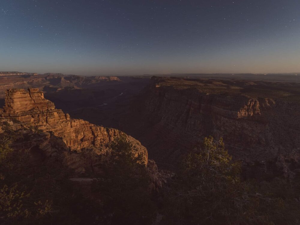
Camping in Grand Canyon National Park: The park has two campgrounds and a full-hookup RV park, as well as several walk-in campsites for hikers along walking trails through the canyon. Mather Campground is the larger of the two campgrounds, located in Grand Canyon Village on the South Rim, with the trailer village for large RVs situated right next door. Camper Services, including the shower and laundry block, dump point and potable water station, are located at the entrance to Mather’s. The second campground accessible by car and a nicer and quieter alternative to Mather’s, in our opinion, is Desert View Campground, located near the East Entrance, at the opposite end of the South Rim to Grand Canyon Village. Even if you don’t stay at Desert View Campground, follow the trodden path that starts between sites 46 and 48 and runs to the edge of the rim and what is arguably the park’s best lookout across the canyon and a large section of the Colorado River.
Camping below the rim always requires a backcountry permit. Apply online or see the staff at the Backcountry Information Center.
Plan your visit: The entrance fee is $35 per vehicle for a 7-day period unless you have the annual America the Beautiful Pass ($80/1 year/2 pass owners), which covers entrance fees at all national parks and many other recreational areas in the States. Included in the permit are the shuttle buses operating in the park along several routes. Particularly in peak season, it’s much easier to board one of the shuttles than to search in vain for a free parking spot.
Please note that trail conditions may have changed since we published this post. For your safety, please verify trail status and conditions on official websites before your trip.