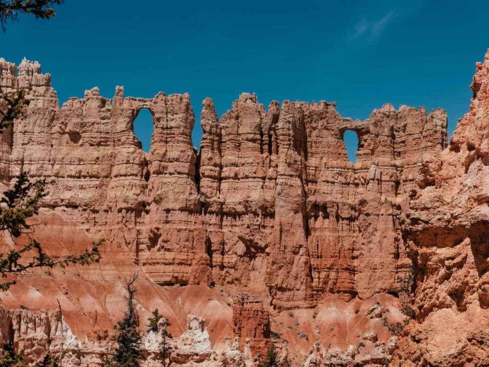
The Queens Garden and Peekaboo Loop runs past many of the Bryce Canyon's striking rock formations, like The Wall of Windows and The Cathedral.

Bryce Canyon is one of the smallest, but also, I believe, the most scenic of the national parks on the Colorado Plateau in southern Utah. The Grand Canyon will make you stare in awe at the vast chasm, 10 miles wide (16km), Arches boasts the largest number of natural stone arches anywhere in the world, and Zion offers a daring and fun walk to the top of Angels Landing.
But no sight will take your breath away quite like the view from Bryce Point, of a magical fairytale castle composed of mushroom-shaped hoodoos, pointed spires, and rows upon rows of pink cliffs bathed in the morning sun. This otherworldly labyrinth, snuggled into the oval shape of the Bryce Amphitheater is marvellous, in its entirety.
But then, each bulbous column in itself is a masterpiece of weathered rock, sculpted by millions of years of erosion. The scenery changes constantly throughout the day as the changing light bathes the columns in ever different vibrant orange and pink hues, and a thousand slender shadows grow shorter and longer, thinner and thicker with the course of the sun underneath a pale blue sky.
Change is the common thread of Bryce Canyon, which at an elevation of up to 9,100 feet (2780m) above sea level experiences significant temperature fluctuations between night and day, a phenomenon called frost wedging or ice wedging. On roughly 180 days a year, warm daytime temperatures melt the snow and ice, allowing water to seep into cracks and crevices. Come nighttime, and that water freezes again, expanding in the process, causing fissures and cracks and toppling even the most beautiful pinnacles.
I was glad not to witness any hoodoos crumble by this invisible force of weathering and erosion, thinking that the maze was perfect and that any change would be for the worse. It took me some time to realize that it was erosion in the first place that formed the hoodoos and that, unlike human-caused destruction, the changes caused by nature in Bryce were creating something new that was equally beautiful or even more so.
The Bryce Amphitheater with its fine-grained pink hoodoos, cliffs, and columns sits at the top of what is called the Grand Staircase, an area described as “the world’s most complete sequence of sedimentary rocks” that was once submerged under an inland sea and has layers of rock more than 200 million years old.
If you have the time, you can visit the Grand Canyon, Zion and Bryce one after the other, climbing the giant steps of the Grand Staircase, so to speak. You won’t perceive the area as a staircase, of course, but I have never been more fascinated by plain, old rock than I was in Utah’s national parks.
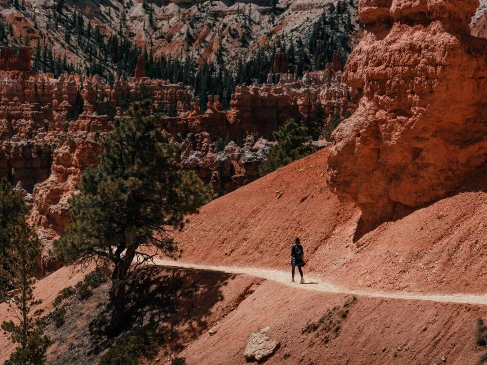
Hiking in Bryce Canyon National Park is very very popular and unlike the Grand Canyon, descending below the rim to the floor of Bryce Canyon on well-maintained hiking trails with fairly gentle elevation gains is a very doable endeavour for most people. The most popular hikes in Bryce Canyon are the Navajo Loop and Queen’s Garden Trail, as they are both short but very scenic trails and can be combined into a slightly longer 3-mile (5km) loop. Even the longer, more challenging Fairyland and Queens Garden-Peekaboo loops were gentle walks compared to the South Kaibab-Tonto-Bright Angel and Grandview-Tonto-Hance Creek hikes in the Grand Canyon.
If you’re looking for a level, wheelchair-friendly walkway, Bryce doesn’t measure up to the Grand Canyon‘s paved 2.8-mile (4.5km) Hermit Road section of the Greenway Trail, however. The only paved section of the Rim Trail at Bryce Canyon is the 1-mile (1.6km) stretch between Sunset and Sunrise Points.
The desert climate and high elevation make for chilly nights and surprisingly warm days. Take plenty of layers to prepare for these temperature changes – especially when you visit in summer and head out for a night walk, which you absolutely should do as Bryce Canyon has some of the world’s darkest night skies and spectacular stargazing. Don’t forget to take a headlamp.
If you’re not an enthusiastic hiker, the best way to see the canyon is to follow the Scenic Drive as it traces the plateau rim for 18 miles (29 km). There are plenty of opportunities to pull out at scenic viewpoints and follow short trails to the rim for great views of the canyon.
1. Fairyland Loop Trail in Bryce Canyon
Hike | Loop trail | 3 hours
2. Navajo Loop Trail in Bryce Canyon
Hike | Loop trail | 45 min
Walk | Out & back trail | up to several hours
4. Queens Garden and Peekaboo Loop Trail
Hike | Loop trail | 2.5-3 hours


Well-maintained hiking trails that allow you to see the most stunning hoodoo formation in the Bryce Amphitheatre close-up
The Scenic Drive traces the plateau rim for 18 miles (29 km) with plenty of opportunities to pull out at scenic viewpoints
Where and getting there: Bryce Canyon National Park is located in southwestern Utah, a 4-hour drive from Las Vegas and Salt Lake City.
All of the park’s visitor facilities are located at Bryce Amphitheatre: the visitor center, Bryce Canyon Lodge and restaurant, both of the park’s frontcountry campgrounds (North Campground and Sunset Campground), and the general store (shower and laundry facilities and a very limited selection of food items). Also many of the park’s most spectacular and easily accessible hiking trails start here.
Where to stay: Bryce Canyon Lodge offers accommodation inside the park and many more motels and hotels are located in Bryce Canyon City and accessible via the free shuttle bus. Additionally, two park managed campgrounds are located in the national park (commercially operated campgrounds are located in Bryce Canyon City), North Campground (first-come, first-served; usually fills up first; RV dump station; loop A open in winter) and Sunset Campground (can be reserved; closed in winter; separate tent-only loop).
Where to eat: Bryce Canyon Lodge offers breakfast, lunch and dinner and the General Store sells a very limited selection of fast-food meals and grocery items. Head to Bryce Canyon City for more dining options and Ruby’s Inn General Store for a limited selection of groceries and souvenirs. If you’re staying in the national park for some time, it’s probably best to stock up on groceries at a larger supermarket before you arrive.
When to go: From May to September you can expect fairly warm daytime temperatures and there shouldn’t be any snow. The season is quite short because Grand Canyon lies at an elevation of up to 9,100 feet (2780m) above sea level and nighttime temperatures can drop well below zero in autumn and spring. When we visited in May, nighttime temperatures dropped to -11°C (12°F). In winter, even early spring and late autumn, a lot of the trails will very likely be closed. Prepare for heat in summer.
How to get around: Although you’ll proably drive to Bryce in your own car, once you’re there, it’s often much easier to take the free Bryce Amphitheater Shuttle Service provided that connects the park’s viewpoints and facilities within the Bryce Amphitheater area from mid-April through mid-October.
How to prepare: If you’re visiting and camping in peak season, book your site well in advance. Also, take warm clothes, even in summer, as nighttime temperatures usually fall below freezing from October to April and drop to single digits during the rest of the year. Wear hiking shoes with proper grip and taking hiking poles will be useful on the slippery downhill sections.
Permits: The entrance fee is $35 per vehicle for 7 consecutive days unless you have the annual America the Beautiful Pass ($80/1 year/2 pass owners), which covers entrance fees at all national parks and many other recreational areas in the States. For further information visit the National Park Service website.
The fabulous Bryce Canyon Rim Trail
Most people who visit Bryce Canyon flock to the popular section of the Rim Trail, the 0.5-mile (0.8km) paved and wheelchair-accessible stretch between Sunrise and Sunset Points. The two scenic lookouts sit right on the rim above the Bryce Amphitheatre and offer the best aerial panoramas of the national park’s most impressive rock formations, particularly at sunrise and sunset when thousands of hoodoos glow in vibrant pink and orange colours.
If you don’t mind a longer walk on a gently undulating dirt track, you can escape the crowds and visit many more scenic overlooks by taking the free shuttle to either Fairyland Point or Bryce Point, the two endpoints of the Rim Trail, and walk back towards Sunrise or Sunset Points.
The total distance of the Rim Trail is 5.5 miles (9.2km), with a 535m elevation gain walking south (Fairyland Point – Bryce Point) and a 375m elevation gain heading north (Bryce Point – Fairyland Point).
Please note that trail conditions may have changed since we published this post. For your safety, please verify trail status and conditions on official websites before your trip.